1 .PEÑA CORTADA
Distance: 32 Km (approx)
Minimal height: 349 m. Streets
Maximum Height: 940 m.Collado of the Air.
Difference: 577 m.
Difficulty of the route: Easy. Cycling 100%.
Time spent: About 3 hours and 45 minutes.
______________________________________________________________
ROUTE BOOK
This route begins in Calles (349 mts) a village of the Province of Valencia, more specifically in its cemetery where we will take an asphalted road, after 2 km we arrive at a small bridge where we will find a poster that reads “Mount of utility publishes Los Rodenos. “
Here we take the main track and start climbing, after 3 km we arrive at Collado de las Saletas and keep going up to the left, we will pass through an indicator that says “Fuente Mas de Solaz”, we continue along the main track always straight.
On the 9 km, we will see that a road goes to our right but you have to continue straight ahead, we continue climbing and we arrive at the highest point of the route Collado del Aire (940 mts), we continue 2 km more and we arrive at the indicator of ” Mas Herrero “where the descent ends, we leave the main track to go to the left following the direction of the indicator, down the road, about 300 meters we start a small climb to our left leaving the road that goes down to the ravine.
We found an indicator of “Mas Herrero” but in the opposite direction to ours (good sign since if it is so, it is that you are going well), continue descending by our left, and on the 16 km we arrive at the Rambla de Alcotas, we turn to the left and follow the direction of the rambla for a track in very good condition. After doing about 4 km of very good track and downhill, you have to have your eyes wide open. Attention, fields of olive trees, next to two indicators left the main track where we came and take a road to the left following the direction of the wooden indicator in which “Peña Cortada”.
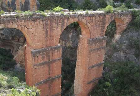
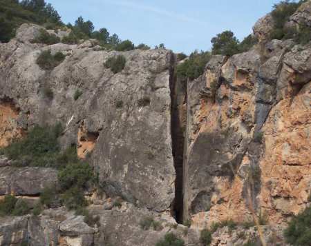
We are about km 21 approx. , we cross the ravine and continue straight ahead (do not take the road that goes up to our left), after passing some ruins of the aqueduct we continue facing. Well we are already in km 22, front we will see that the ravine is cut by a pile of rocks, on our left we take an entrance to an almond field, when arriving at a plain we get off our bikes and look for a path that climbs to where are the highest almonds. Upon reaching the almond trees we continue along the path to the right which after a few moments will become an ancient aqueduct. After arriving at the aqueduct you will find the Peña Cortada and a large number of tunnels, we are at km 23 we have reached the end of this technical tour so we have to return.
After completing the 2 km. Aprox, back by the same road that we have reached the Peña Cortada, we will be at the crossroads of the wooden sign that indicated “Peña Cortada” when we passed for km 21, well when we reach the main road again we turn left and continue straight ahead, after 2 km we reach the road to Ahillas, take the road to get to Chelva, we arrive at Chelva we turn to our left in direction to Valencia and down to Calles down the road. Arriving at Calles we turn left towards the cemetery, where this route ends.
It is a very easy route to do, with only a more technical stretch that is the tunnel by the fact that it is rubbed a little by the walls, it is simply a matter of going slowly and carefully. The first stretch up to Collado del Aire is the one that offers the most difficulty on a physical level since it is all up (9 km aprox). In turn this route we can say that it is a little strange more than anything because you do not expect the whole theme of the tunnels that you will see as you will like it very much.
This route has been provided by Juanjo Maqueda, from Valencia (redbull at rutasbike.com), to which we are very grateful. We hope the route is to your liking. Good Route.